Why place names matter
Place names are a key component of how we locate our place in the world and how we can tell stories and share history.
Naming or renaming new roads, suburbs and geographical features should be community driven, submitted via your relevant local government and approved by Landgate.
All naming decisions in WA are made in line with our Policies and Standards for Geographic Naming in Western Australia, which are aligned to national and international naming best practice.
Did you know?
Yebble is one of the state’s newest localities. Situated on the coast in the Shire of Augusta Margaret River, its name was proposed to honour Samuel Isaacs for his role in rescuing passengers from the wreck of the SS Georgette in 1876.
Yebble is Mr Isaacs’ Wadandi Noongar name given to him at birth by his mother Darinder. Together with Grace Bussell (who Gracetown was named after), they saved 50 passengers off the coast near present day Redgate.
Mr Isaacs was later awarded a Bronze medallion from the Royal Humane Society and later farmed his own freehold property, Fernbrook, on the banks of the Margaret River. Take a closer look at the area on Map Viewer Plus.
Who manages place naming in WA?
Landgate is responsible for managing the nomenclature needs (the system for assigning names) for geographical features, administrative boundaries, localities and roads.
We are also responsible for maintaining the State's Gazetteer, GEONOMA (geo = geographic, noma = Latin for 'name') the nomenclature database. The database contains official names and geographical coordinates of geographic features in the state. This includes the official spelling of the name, feature type, classification, derivation, map number, coordinates and any alternative and historical names.
GEONOMA is recognised by the WA Government as the primary source and official register for all approved named geographic features, administrative boundaries, localities and road names and their positions and/or extents.
How are WA roads, features or localities named?
A toponym is a place name arising from a geographical feature. In naming we manage the assigning of toponyms to represent sites of human occupation (such as cities or towns), natural geographic features (such as mountains, lakes or bays) and bounded areas (such as localities).
Toponyms are a means of public and personal reference for location description and identification and also provide information about where a place is, what is there and key elements of maps and marine charts.
What are the rules for naming or renaming places?
Imagine a world without standardised naming and addressing. Emergency services wouldn’t know where to go, local governments wouldn’t know the boundaries of their jurisdiction and your mail and other deliveries would never arrive because there would be no way to locate you. Your GPS would send you off somewhere unknown or simply not find where you want to go.
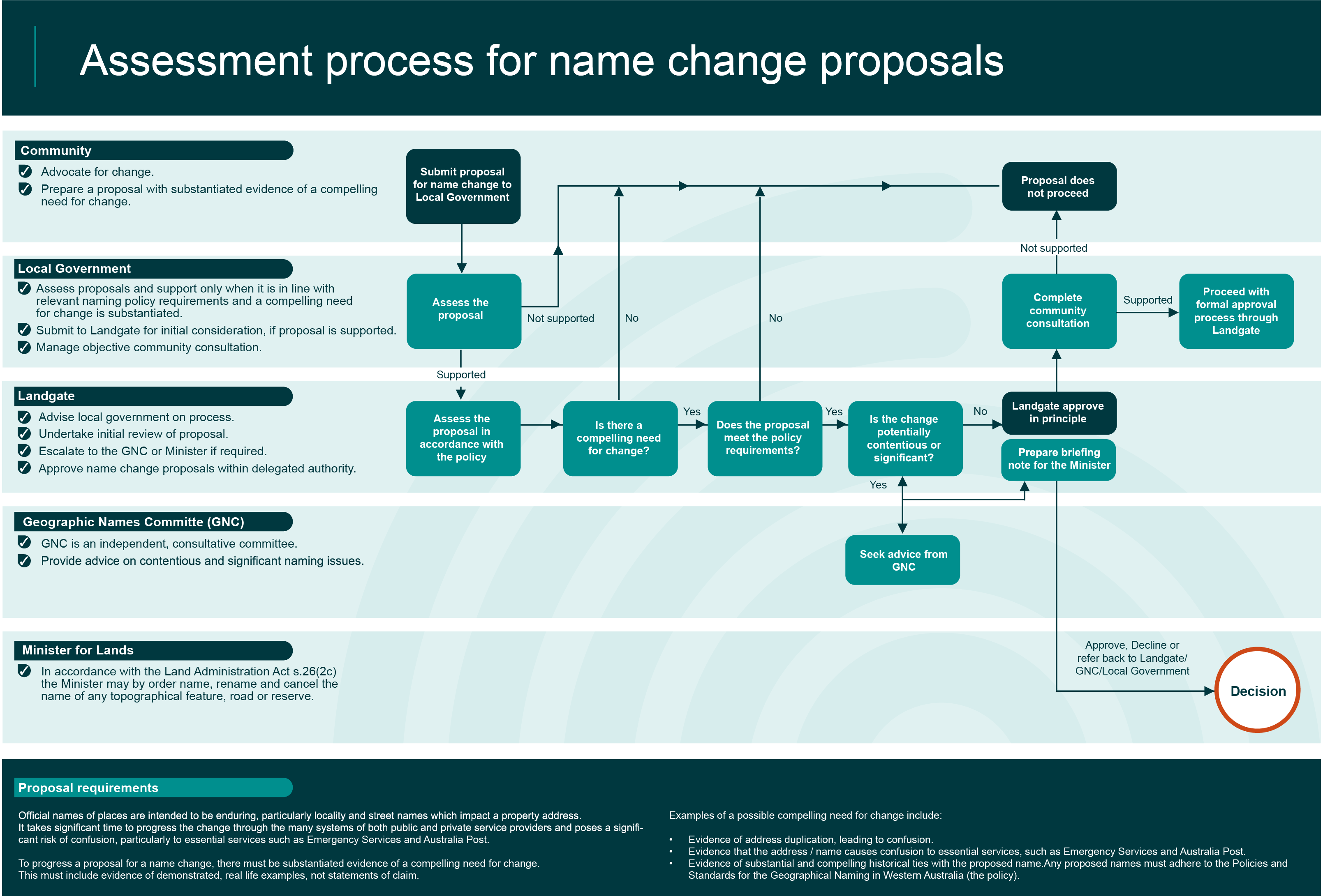
Find out more about the naming process with the flowchart below.

At Landgate, we apply two key governing documents when we consider place naming:
- Policies and Standards for the Geographical Naming of Western Australia.
- Aboriginal Naming Guidelines
The rules outlined in these documents apply to all proposed names, existing names being considered for renaming and dual naming, and removing names that are no longer in use or suitable.
Local governments provide all naming submissions to Landgate. Members of the public with suggestions or corrections to place names should contact the local government or Landgate for further assistance.
The Australian Standard for Rural and Urban Street Addressing (ASNZ4819) is also applied to ensure national consistency for address assignment. The structure of street names is aligned to AS4590, which enables standardised sharing of data.
The current Aboriginal Naming Guidelines were published in 2020 and released as a separate document following extensive consultation, including local governments and Aboriginal corporations.
How to check an address
We maintain a whole-of-state address database to support the registration of property ownership. You can verify your address here
Addresses are assigned and maintained by the relevant local government and provided to Landgate when a new subdivision occurs. Amendments and changes to existing street addresses are also allocated by the local government, which then advises Landgate.
Want to know more about naming?
The Geographic Names Committee is an advisory body to Landgate and the Minister for Lands. Read more about the important role the committee plays here.
